


Navionics Platinum+ XL3
£282.50 ex VAT
In Stock
Description
NAVIONICS PLATINUM+ XL3
Platinum+ marine charts provide you with Navionics+ charts and features, plus 3D View, satellite overlay and panoramic photos.
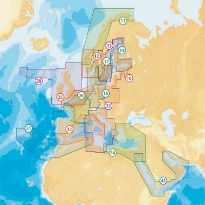
CHART COVERAGE AREAS FOR NORTH EUROPE & MEDITERRANEAN
- 11P-Norway North West
- 12P-Norway South West
- 13P-Sweden East Coast
- 14P-Finland
- 15P-Oslo to Denmark
- 16P-South Baltic
- 17P-Sweden South
- 25P-UK South to Hamburg
- 26P-France
- 28P-UK, Ireland, North France & Holland
- 31P-Atlantic Coast & Western Mediterranean
- 32P-Mediterranean West
- 33P-Mediterranean Central
- 34P-Mediterranean East
- 43P-Red Sea & Arabian Gulf
Please ensure you provide you Plotter Make & Model under the notes section at checkout to ensure the correct card is supplied.
Additional information
| Weight | 0.5 kg |
|---|---|
| Dimensions | 19 × 14 × 1 cm |
| Format | SD/MSD Card, Compact Flash |
| Chart Area | 11P+ Norway North West, 12P+ Norway South West, 13P+ Sweden East Coast, 14P+ Finland, 15P+ Oslo to Germany, 16P+ South Baltic, 17P+ Sweden South, 25P+ UK South to Hamburg, 26P+ France, 28P+ UK & Ireland, 31P Iberia, 32P+ Mediterranean West, 33P+ Central Mediterranean, 34P+ Mediterranean East, 43P+ Red Sea & Arabian Gulf |
Related Products
-
£229.99 ex VATFormat : SD/MSD Card - Compact Flash
-
£229.99 ex VATFormat : SD/MSD Card - Compact Flash
-
£282.50 ex VATFormat : SD/MSD Card - Compact FlashChart Area : 5P158XL Bay of Biscay/Spain - 5P159XL Portugal to Azores - 5P253XL Black Sea - 5P268XL North Aegean Sea - 5P269XL Mediterranean South East - 5P270XL South Aegean Sea - 5P271XL Adriatic Sea - 5P272XL Central Mediterranean - 5P273XL Tyrrenian Sea - 5P274XL Mediterranean North West - 5P275XL Mediterranean South West - 5P391XL Strait of Dover - 5P392XL English Channel - 5P393XL Irish Sea - 5P394XL Ireland - 5P396XL Scotland West - 5P397XL Eastern UK - 5P398XL Hamburg/Dunkerque - 5P399XL Germany West/Denmark West - 5P400XL Stockholm to ?hus - 5P403XL Northern Norway - 5P404XL Estonia to Poland - 5P405XL Gulf of Finland - 5P406XL Gustavsvik/Aaland I. - 5P407XL Swedish Lakes - 5P409XL Arendal ? Sognefjorden - 5P410XL Skagerrak - 5P411XL Gulf of Bothnia - 5P412XL Kasko to Vormsi - 5P413XL Kristiansund to Bergen - 5P414XL Nesna to Smoela - 5P415XL Ringvassoey to Nesna - 5P416XL Iceland to Faeroe I. - 5P417XL Germany East/Sweden South - 5P445XL Denmark East/Sweden West - 5P446XL Finnish Lakes - 5P538XL Cen. European Lakes - 6P027XL N. Madagascar/Somalia - 6P035XL Africa S.E./Madagascar - 7P016XL Persian Gulf/Oman Gulf - 7P017XL Red Sea/Gulf of Aden - 8P133XL Melbourne/Tasmania - 8P135XL Brisbane to Sydney - 8P136XL Queensland Australia - 8P137XL Australia North-East - 8P138XL Northern Australia - 8P139XL Beagle B. to Perth - 8P140XL Perth to Melbourne - 8P160XL New Zealand
-
£229.99 ex VATFormat : SD/MSD Card - Compact Flash
-
£229.99 ex VATFormat : SD/MSD Card - Compact Flash
-
£184.99 ex VATFormat : SD/MSD Card - Compact Flash