Subtotal: £104.00
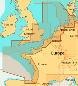
EW-M227 North West European Coasts
£272.00
In StockDescription
C-Map MAX EW-M227 North West European Coasts
Please check the below table for your model of plotter to make sure you have selected the correct format
Please also advise us of your model using the Plotter Model box when placing an order.
MAX Features
- Dynamic NavAids – Detailed information including name, colour, frequency, range of lights.
- Guardian Alarm – Automatic forward scan for obstacles.
- Route-Check – An extension of Guardian Alarm indicates obstacles along segments in between way points.
- Detailed Harbour Charts – Precise layouts of marinas including slip spaces, restricted areas etc.
- C-Marina Port database – Harbour hours, Harbour Master contact info., nearby lodgings and restaurants, VHF call in etc.
- Dynamic Tides and currents – Tide heights and speed and direction of currents.
- Photos and diagrams – Photos of ports and marinas so you can familiarise yourself before arriving.
- Depths and land elevations – Colours make it easy to visualise depths and land elevations.
- Perspective view – Tilt the chart 45° for a bird’s eye view.
- Points of interest and road mapping – Extensive database of local services and cultural highlights.
Additional information
| Weight | 0.5 kg |
|---|---|
| Dimensions | 25 × 15 × 1 cm |
| Publisher | C-MAP by Jeppesen |
| Media | C-Card, SD/MSD Card |
| Format | MAX |

 UK Flag 1.5 Yard
