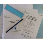
NP727 Wallet Containing Ships Boats Charts & Drawing Materials
£60.75
In Stock1 in stock (can be backordered)
Description
Admiralty Publication NP727 Wallet Containing Ships Boats Charts & Drawing Materials
The Admiralty NP727 Ships’ Boats Charts and Drawing Materials is designed to provide a level of navigational information to help a mariner in a lifeboat make informed decisions about courses to land/help. The pack contains Admiralty charts that contain coverage of the World’s Oceans, also included are drawing materials, bearings of the sunrise and sunsets and Northern and Southern Latitudes.
All ships are required to carry NP727 under SOLAS regulations.
The items come sealed in a plastic bag containing the following Ships’ Boats Charts:-
- 5211 North Atlantic Ocean Admiralty Chart
- 5212 South Atlantic Ocean Admiralty Chart
- 5213 Indian Ocean (May to October) Admiralty Chart
- 5214 Indian Ocean (November to April) Admiralty Chart
- 5215 North Pacific Ocean Admiralty Chart
- 5216 South Pacific Ocean Admiralty Chart
- Table of Sunrise & Sunset bearings.
- Small polythene envelope containing pencil, paper, rubber and protractor.
Additional information
| Weight | 0.635 kg |
|---|---|
| Dimensions | 30 × 22 × 1.5 cm |
| Format | Soft Cover |
| Publisher | UKHO |
| Author | Admiralty |


